
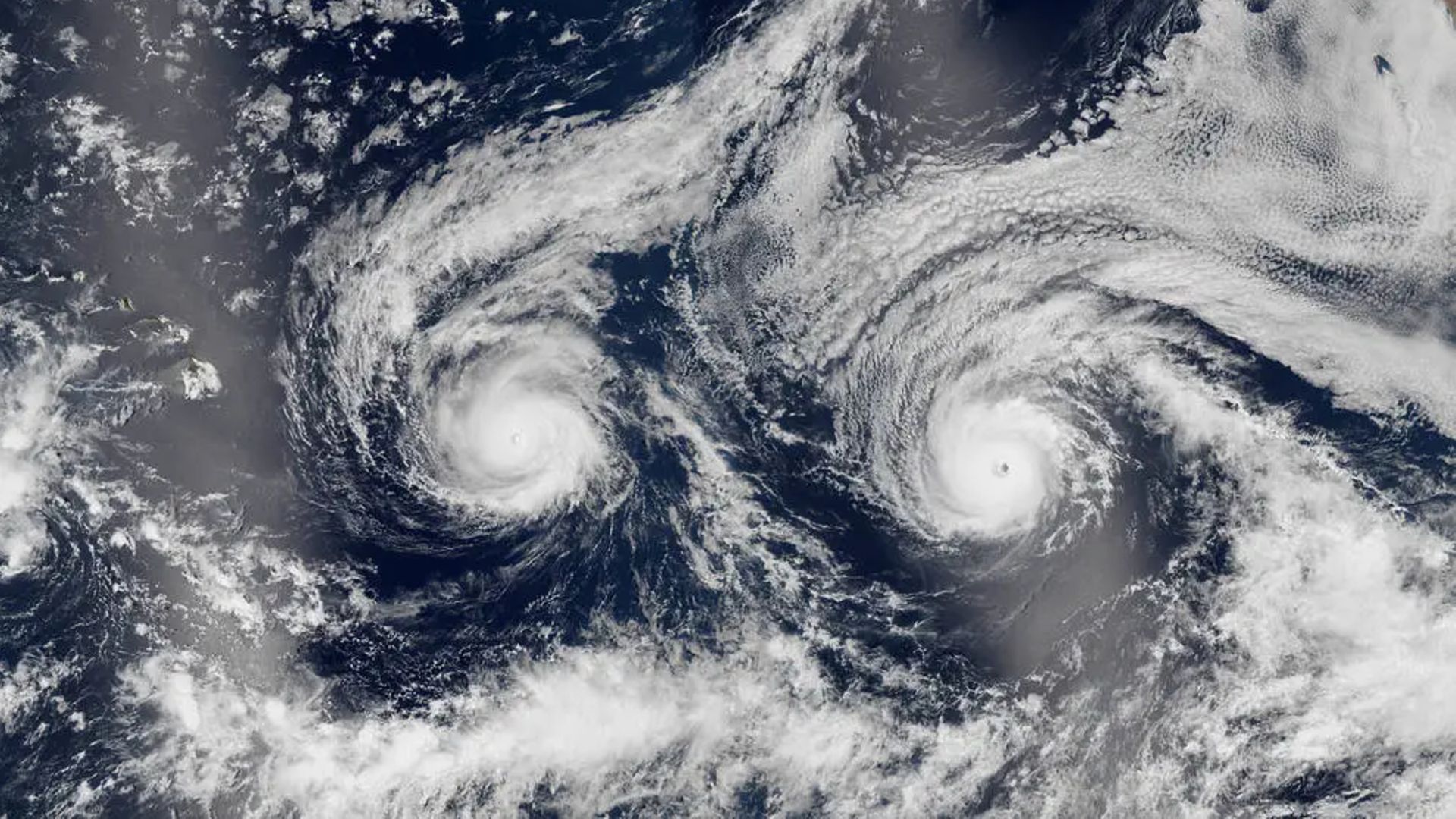
Where is it? Pacific Ocean
What's in the photo? Hurricane Madeline (left) and Hurricane Lester (right)
Which satellite took the photo? Suomi NPP
When was it taken? Aug. 29, 2016
This eye-catching satellite snap from a decade ago shows a pair of hurricanes barreling toward Hawaii. The clouds swirling around the twin cyclones make them look eerily like the eyes of a pale face smiling up at space. The sight appears even spookier when viewed on a weather map (see below).
The surprisingly symmetrical storms — Hurricane Madeline (left) and Hurricane Lester (right) — were the 14th and 13th named storms, respectively, during 2016's Pacific hurricane season, which is tied for the sixth-most-active year on record, with 22 total named storms.
Madeline peaked as a Category 4 storm on Aug. 30, reaching maximum wind speeds of around 130 mph (210 km/h). Lester also briefly became a Category 4 storm on Sept. 1, reaching a maximum speed just below Madeline's, but it quickly weakened to Category 3.
On Aug. 30, the day after the image was taken, Madeline was just under 400 miles (650 kilometers) from Hawaii's Big Island, while Lester was around 900 miles (1,450 km) behind on the same trajectory, according to NASA's Earth Observatory. At the time, meteorologists were uncertain whether the pair would hit the island.
The Central Pacific Hurricane Center later issued a hurricane warning for the state of Hawaii, saying that Madeline, in particular, would pass "dangerously close to the Big Island," according to the Earth Observatory. However, neither storm ended up making landfall. (In the photo, the Big Island is obscured by reflected sunlight, known as a sunglint, on the left side of the image.)
When viewed on a radar-based weather map, the hurricanes look like they are staring up into space even more. (Image credit: National Weather Service)Madeline eventually passed south of Hawaii on Aug. 31. However, by then, it had been downgraded to Category 1. Lester passed north of the Big Island on Sept. 2 and came within around 130 miles (210 km) of Honolulu, before sharply turning northward, where it petered out.
Although neither hurricane made landfall — meaning the eye of the storm did not pass over a landmass — they still caused high winds, heavy rainfall and strong surf across the state.
Despite being in the middle of the corridor where most Pacific hurricanes form, Hawaii's islands have surprising good luck in avoiding the supercharged storms.
For example, in 2025, Hurricane Kiko was similarly spotted from space bearing down on the island state. But like Madeline and Lester, it suddenly changed course and weakened at the last minute.
Hawaii usually manages to dodge the worst effects of hurricanes for two reasons. First, the islands are surrounded by a near-constant area of high pressure on their eastern side, where most hurricanes come from. Second, strong winds often blow eastward across the islands, according to FOX Weather. These factors create a sort of invisible shield around the islands, causing storms to skirt around them.
While hurricanes almost never make landfall in Hawaii, they often come close enough to trigger strong gusts of wind on the islands. (Image credit: Smith Collection/Gado/Getty Images)However, given the recent rise in extreme weather events across the globe — caused by human-caused climate change — as well as changes to regional weather patterns, the islands may not stay so lucky forever.
For example, in August and September, two hurricanes — Lowell and Lala — skimmed unusually closely past the island of Kauai, causing a significant amount of damage to power lines, boats and other coastal infrastructure. Researchers think the ongoing "super" El Niño, which officially began in May and has already caused record-breaking sea surface temperatures in the Pacific Ocean, may be partially to blame for these storms, according to The Guardian.
See more Earth from space
A 2016 satellite photo shows nearly a dozen, surprisingly pronounced dark spots swirling in the clouds over Heard Island in the Indian Ocean.
Rare volcanic 'Bull's-eye' cloud
A 2021 satellite photo shows an unusual series of concentric cloud rings that appeared directly above an erupting volcano on La Palma in Spain's Canary Islands.
Swirling Atlantic cloud trails
A 2015 satellite photo captured a series of stunning "von Kármán vortices" swirling off islands in the Atlantic. It is one of the best examples of this meteorological phenomenon ever seen.
Hence then, the article about twin hurricanes stare out to space as they barrel toward hawaii was published today ( ) and is available on Live Science ( Middle East ) The editorial team at PressBee has edited and verified it, and it may have been modified, fully republished, or quoted. You can read and follow the updates of this news or article from its original source.
Read More Details
Finally We wish PressBee provided you with enough information of ( Twin hurricanes stare out to space as they barrel toward Hawaii )


Also on site :
- In 1922, Charles H. ‘Chuck’ Taylor walked into Converse complaining of sore feet; 81 years later, Nike bought the company for $305 million
- Today’s NYT ‘Strands’ Hints, Spangram and Answers for Tuesday, October 27, 2026
- 1960s Carpenters Legend, Whose Solo Album Was Shelved for 16 Years, Named One of the Era’s Most Beautiful Voices