
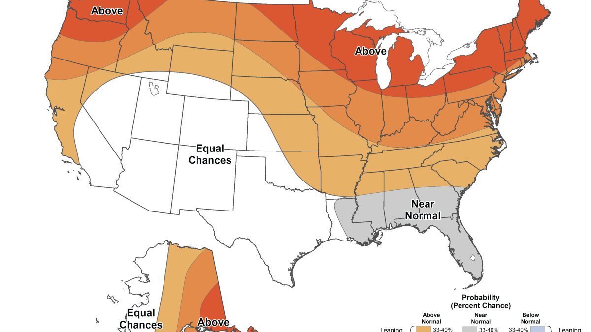
The latest 2026-27 winter weather prediction for the Chicago area is here, and the latest outlook maps are giving a peek into what temperatures could be like over winter months.
The outlook, released Thursday by the National Oceanic Atmospheric Administration, comes as meteorologists warn of an ongoing El Niño pattern strengthening in the Pacific Ocean that’s expected to impact multiple states in different ways, including warmer-than-average temperatures for some parts and wetter-than-average conditions for others.
As part of the prediction, a seasonal temperature outlook map for December, January and February showed temperatures were likely to lean above average in the Chicago area for those months. According to NOAA, the the greatest chances overall for warmer-than-average conditions would be in the Pacific Northwest, northern Rockies, the Midwest, Mississippi Valley and much of the East and Alaska.
No states looked to be below-normal for temperatures this winter, the map showed.
The NWS says the average high temperature for December, is about 30 degrees, In January, the average temperature for Chicago is around 25 degrees, with an average of about 28 degrees in February.
NOAA’s winter outlook also contained a map of seasonal precipitation predictions, which showed equal chances for above or below-average precipitation.
‘Coldest night of the season:’ Frost advisory, freeze warning issued for parts of Chicago area
“Wetter-than-average conditions are most likely across the southern tier, from the Southwest to the Southeast, and along the East Coast,” the outlook said. “Elevated odds for drier-than-average conditions for Hawaii, much of Alaska, the northern Mountain West, some areas in the Great Lakes and the western Pacific Islands.”
According to a report from the University of Illinois, the Chicago area typically sees around two inches of liquid precipitation per month during the winter. For snowfall, the Chicago area typically sees an average of seven inches of snow in December, followed by an average of 11 inches of snow in both January and February.
“Even though our winter is expected to be warmer than average, we can still get snow storms,” NBC 5 Storm Team meteorologist Kevin Jeanes said. “However, if we do get a big snow event, that snow probably won’t stick around on the ground very long.”
Jeanes warned that while a mild winter might sound nice, the Chicago area could in turn see more days with a mix of sleet, snow or freezing rain rather than all snow. So it’s still important to stay prepared for slick driving conditions.
Hence then, the article about winter weather outlook what the latest maps show for temperatures snow in the chicago area was published today ( ) and is available on NBC Chicago ( Middle East ) The editorial team at PressBee has edited and verified it, and it may have been modified, fully republished, or quoted. You can read and follow the updates of this news or article from its original source.
Read More Details
Finally We wish PressBee provided you with enough information of ( Winter weather outlook: What the latest maps show for temperatures, snow in the Chicago area )


Also on site :
- Hallmark Channel Stars Pop Up in Small Community, Just Named America’s ‘Merriest Christmas Town,’ for Top Secret Celebration
- CoreWeave investor explains how the loss-making AI ‘neocloud’ provider plans to claw its way out of debt
- Shoppers Are Buying Walmart’s $10 ‘Buttery-Soft’ Long-Sleeve in Multiple Colors — It’s a ‘Great Fall Basic’